| dc.coverage.spatial | W 85°--W 74°/N 25°00'--N 17°20' | en |
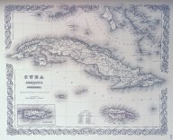
| dc.coverage.spatial | Cuba | en |
| dc.coverage.spatial | Jamaica | en |
| dc.coverage.spatial | Puerto Rico | en |
| dc.creator | J.H. Colton & Co. | |
| dc.date.accessioned | 2012-09-27T16:52:40Z | |
| dc.date.available | 2012-09-27T16:52:40Z | |
| dc.date.issued | 1856 | |
| dc.identifier.uri | https://hdl.handle.net/1969.1/146841 | |
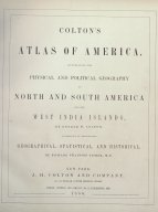
| dc.description | 1 map (2 views including map and the title page of larger atlas) | en |
| dc.description | Appears in Colton's Atlas of America : illustrating the physical and political geography of North and South America and the West India islands. (1856) | en |
| dc.description | Includes table of reference for parishes in Jamaica. | en |
| dc.description.abstract | Shows political boundaries, cities, natural features, and railroads in Cuba | en |
| dc.language.iso | eng | |
| dc.publisher | New York : J.H. Colton & Co., 1856. | |
| dc.relation.ispartof | Colton, G. Woolworth (George Woolworth), 1827-1901. Colton's atlas of America: Illustrating the physical and political geography of North and South America and the West India Islands | en |
| dc.rights | No Copyright - United States | en |
| dc.rights.uri | http://rightsstatements.org/vocab/NoC-US/1.0/ | |
| dc.subject.lcsh | Cuba --Maps | en |
| dc.subject.lcsh | Jamaica --Maps | en |
| dc.subject.lcsh | Puerto Rico --Maps | en |
| dc.subject.lcsh | Railroads --Cuba --Maps | en |
| dc.title | Cuba, Jamaica and Porto Rico | en |
| dc.type | Map | en |
| dc.coverage.box | northlimit=25.74; westlimit=-85.85; southlimit=16.34; eastlimit=-73.30 | en |
| dc.rights.requestable | FALSE | en |