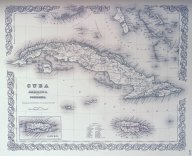
Cuba, Jamaica and Porto Rico
Abstract
Shows political boundaries, cities, natural features, and railroads in Cuba
Description
1 map (2 views including map and the title page of larger atlas)Appears in Colton's Atlas of America : illustrating the physical and political geography of North and South America and the West India islands. (1856)
Includes table of reference for parishes in Jamaica.
Collections
Citation
(1856). Cuba, Jamaica and Porto Rico. New York : J.H. Colton & Co., 1856.. Available electronically from https : / /hdl .handle .net /1969 .1 /146841.