| dc.coverage.spatial | Cuba | en |
| dc.creator | Bennett, H. H. | |
| dc.creator | Allison, R. V. | |
| dc.creator | Tropical Plant Research Foundation (U.S.) | |
| dc.creator | United States. Bureau of Soils | |
| dc.date.accessioned | 2012-02-28T19:53:12Z | |
| dc.date.available | 2012-02-28T19:53:12Z | |
| dc.date.issued | 1928 | |
| dc.identifier.other | 1198261 | |
| dc.identifier.uri | https://hdl.handle.net/1969.1/128935 | |
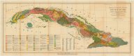
| dc.description | Also shows railroads, "central highway," and location of sugar mills. Includes "List of centrals in Cuba by province." | en |
| dc.language.iso | eng | |
| dc.publisher | Tropical Plant Research Foundation | |
| dc.rights | No Copyright - United States | en |
| dc.rights.uri | http://rightsstatements.org/vocab/NoC-US/1.0/ | |
| dc.subject.lcc | G4921.J3 1928 .B4 | en |
| dc.subject.lcsh | Soils --Cuba --Maps | en |
| dc.title | Soil map of Cuba: 1928 | en |
| dc.type | Map | en |
| dc.coverage.box | northlimit=23.84; westlimit=-85.45; southlimit=19.10; eastlimit=-73.55 | en |