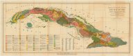
Soil map of Cuba: 1928
Date
1928Metadata
Show full item recordDescription
Also shows railroads, "central highway," and location of sugar mills. Includes "List of centrals in Cuba by province."Collections
Citation
(1928). Soil map of Cuba: 1928. Tropical Plant Research Foundation. Available electronically from https : / /hdl .handle .net /1969 .1 /128935.