| dc.coverage.spatial | North Dakota | en |
| dc.creator | Willard, Daniel E. (Daniel Everett), b. 1862. | |
| dc.date.accessioned | 2006-06-19T18:16:58Z | |
| dc.date.accessioned | 2012-06-02T03:38:49Z | |
| dc.date.available | 2006-06-19T18:16:58Z | |
| dc.date.available | 2012-06-02T03:38:49Z | |
| dc.date.issued | 1909 | |
| dc.identifier.govdoc | I19.5/1:168 | |
| dc.identifier.uri | https://hdl.handle.net/1969.1/3602 | |
| dc.description | Jamestown-Tower folio, Jamestown, Eckelson, and Tower quadrangles, North Dakota | en |
| dc.format.extent | 108386288 bytes | en |
| dc.format.extent | 108484703 bytes | en |
| dc.format.extent | 108686150 bytes | en |
| dc.format.extent | 108361016 bytes | en |
| dc.format.extent | 108236357 bytes | en |
| dc.format.extent | 108386288 bytes | en |
| dc.format.extent | 108510704 bytes | en |
| dc.format.extent | 107712206 bytes | en |
| dc.format.extent | 108309014 bytes | en |
| dc.format.extent | 108986012 bytes | en |
| dc.format.extent | 108211328 bytes | en |
| dc.format.extent | 108886625 bytes | en |
| dc.format.extent | 117249257 bytes | en |
| dc.format.extent | 108236357 bytes | en |
| dc.format.extent | 108660392 bytes | en |
| dc.format.extent | 108959768 bytes | en |
| dc.format.extent | 107728712 bytes | en |
| dc.format.extent | 108861596 bytes | en |
| dc.format.extent | 109037042 bytes | en |
| dc.format.extent | 108536219 bytes | en |
| dc.format.extent | 107712206 bytes | en |
| dc.format.extent | 106780292 bytes | en |
| dc.format.extent | 108211328 bytes | en |
| dc.format.extent | 108536219 bytes | en |
| dc.format.mimetype | image/tiff | |
| dc.format.mimetype | image/tiff | |
| dc.format.mimetype | image/tiff | |
| dc.format.mimetype | image/tiff | |
| dc.format.mimetype | image/tiff | |
| dc.format.mimetype | image/tiff | |
| dc.format.mimetype | image/tiff | |
| dc.format.mimetype | image/tiff | |
| dc.format.mimetype | image/tiff | |
| dc.format.mimetype | image/tiff | |
| dc.format.mimetype | image/tiff | |
| dc.format.mimetype | image/tiff | |
| dc.format.mimetype | image/tiff | |
| dc.format.mimetype | application/pdf | |
| dc.format.mimetype | image/tiff | |
| dc.format.mimetype | image/tiff | |
| dc.format.mimetype | image/tiff | |
| dc.format.mimetype | image/tiff | |
| dc.format.mimetype | image/tiff | |
| dc.format.mimetype | image/tiff | |
| dc.format.mimetype | image/tiff | |
| dc.format.mimetype | image/tiff | |
| dc.format.mimetype | image/tiff | |
| dc.format.mimetype | image/tiff | |
| dc.language.iso | en_US | |
| dc.publisher | Geological Survey (United States) | |
| dc.relation.ispartofseries | Geologic Atlas of the United States | |
| dc.relation.ispartofseries | 168 | |
| dc.rights | No copyright; for more information see: https://rightsstatements.org/page/NoC-US/1.0/ | en |
| dc.rights.uri | https://rightsstatements.org/page/NoC-US/1.0/ | |
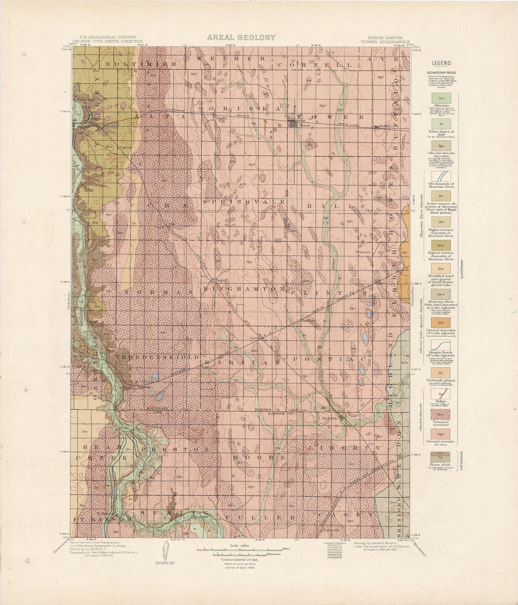
| dc.subject | Neogene - Lower terrace deposits of Sheyenne and James river systems; Highest terrace deposits of Sheyenne river; Stratified sand and gravel of Sand Prairie glacial lake; Approximate shore line of Sand Prairie glacial lake; Sheyenne river delta sand deposited in Lake Agassiz; Littoral deposits of Lake Agassiz; Herman Beach of Lake Agassiz | en |
| dc.subject | Cretaceous - Pierre shale | en |
| dc.subject.lcsh | Groundwater -- North Dakota -- Cass County -- Maps | en |
| dc.subject.lcsh | Groundwater -- North Dakota -- Barnes County -- Maps | en |
| dc.subject.lcsh | Geology -- North Dakota -- Ransom County -- Maps | en |
| dc.subject.lcsh | Geology -- North Dakota -- Cass County -- Maps | en |
| dc.subject.lcsh | Geology -- North Dakota -- La Moure County -- Maps | en |
| dc.subject.lcsh | Groundwater -- North Dakota -- La Moure County -- Maps | en |
| dc.subject.lcsh | Geology -- North Dakota -- Stutsman County -- Maps | en |
| dc.subject.lcsh | Groundwater -- North Dakota -- Stutsman County -- Maps | en |
| dc.subject.lcsh | Geology -- North Dakota -- Barnes County -- Maps | en |
| dc.subject.lcsh | Geology -- United States --Maps | en |
| dc.subject.lcsh | Groundwater -- North Dakota -- Ransom County -- Maps | en |
| dc.title | Jamestown-Tower folio, Jamestown, Eckelson, and Tower quadrangles, North Dakota | en |
| dc.type | Map | en |
| dc.type | Image | en |
| dc.type | Book | en |
| dc.coverage.box | northlimit=47; westlimit=-99; southlimit=46.5; eastlimit=-97.5 | en |
| dc.coverage.point | 46:30:00N97:30:00W | en |