| dc.coverage.spatial | California | en |
| dc.creator | Turner, Henry Ward, b. 1857. | |
| dc.date.accessioned | 2006-04-11T20:35:11Z | |
| dc.date.accessioned | 2012-06-02T05:27:26Z | |
| dc.date.available | 2006-04-11T20:35:11Z | |
| dc.date.available | 2012-06-02T05:27:26Z | |
| dc.date.issued | 1897 | |
| dc.identifier.govdoc | I19.5/1:43 | |
| dc.identifier.uri | https://hdl.handle.net/1969.1/3041 | |
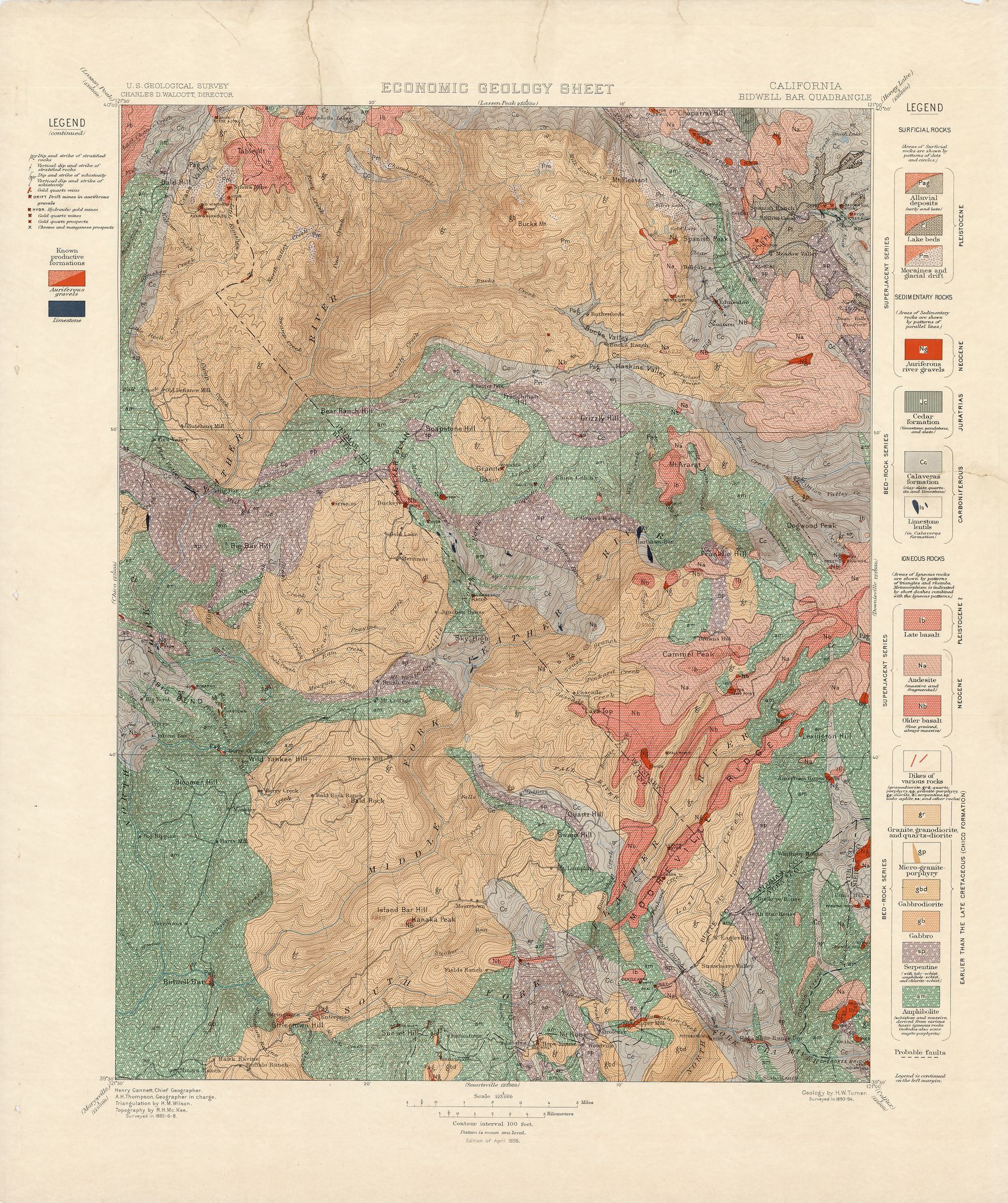
| dc.description | Bidwell Bar folio, California | en |
| dc.format.extent | 106138880 bytes | en |
| dc.format.extent | 107122688 bytes | en |
| dc.format.extent | 105878528 bytes | en |
| dc.format.extent | 106500608 bytes | en |
| dc.format.extent | 106656128 bytes | en |
| dc.format.extent | 61530861 bytes | en |
| dc.format.extent | 106034048 bytes | en |
| dc.format.extent | 107361728 bytes | en |
| dc.format.extent | 106835648 bytes | en |
| dc.format.extent | 107612288 bytes | en |
| dc.format.extent | 107410112 bytes | en |
| dc.format.extent | 108009728 bytes | en |
| dc.format.mimetype | image/tiff | |
| dc.format.mimetype | image/tiff | |
| dc.format.mimetype | image/tiff | |
| dc.format.mimetype | image/tiff | |
| dc.format.mimetype | image/tiff | |
| dc.format.mimetype | image/tiff | |
| dc.format.mimetype | image/tiff | |
| dc.format.mimetype | image/tiff | |
| dc.format.mimetype | image/tiff | |
| dc.format.mimetype | image/tiff | |
| dc.format.mimetype | image/tiff | |
| dc.format.mimetype | application/pdf | |
| dc.language.iso | en_US | |
| dc.publisher | Geological Survey (United States) | |
| dc.relation.ispartofseries | 43 | |
| dc.relation.ispartofseries | Geologic Atlas of the United States | |
| dc.rights | No copyright; for more information see: https://rightsstatements.org/page/NoC-US/1.0/ | en |
| dc.rights.uri | https://rightsstatements.org/page/NoC-US/1.0/ | |
| dc.subject | Carboniferous - Calaveras formation | en |
| dc.subject | Neogene - unnamed strata | en |
| dc.subject | Triassic - Cedar formation | en |
| dc.subject | Cretaceous - unnamed strata | en |
| dc.subject | Jurassic - Cedar formation | en |
| dc.subject.lcsh | Geology -- California -- Yuba County -- Maps | en |
| dc.subject.lcsh | Geology -- United States --Maps | en |
| dc.subject.lcsh | Geology -- California -- Sierra County -- Maps | en |
| dc.subject.lcsh | Geology -- California -- Butte County -- Maps | en |
| dc.subject.lcsh | Geology -- California -- Plumas County -- Maps | en |
| dc.title | Bidwell Bar folio, California | en |
| dc.type | Book | en |
| dc.type | Map | en |
| dc.type | Image | en |
| dc.coverage.box | northlimit=40; westlimit=-121.5; southlimit=39.5; eastlimit=-121 | en |
| dc.coverage.point | 39:30:00N121:00:00W | en |