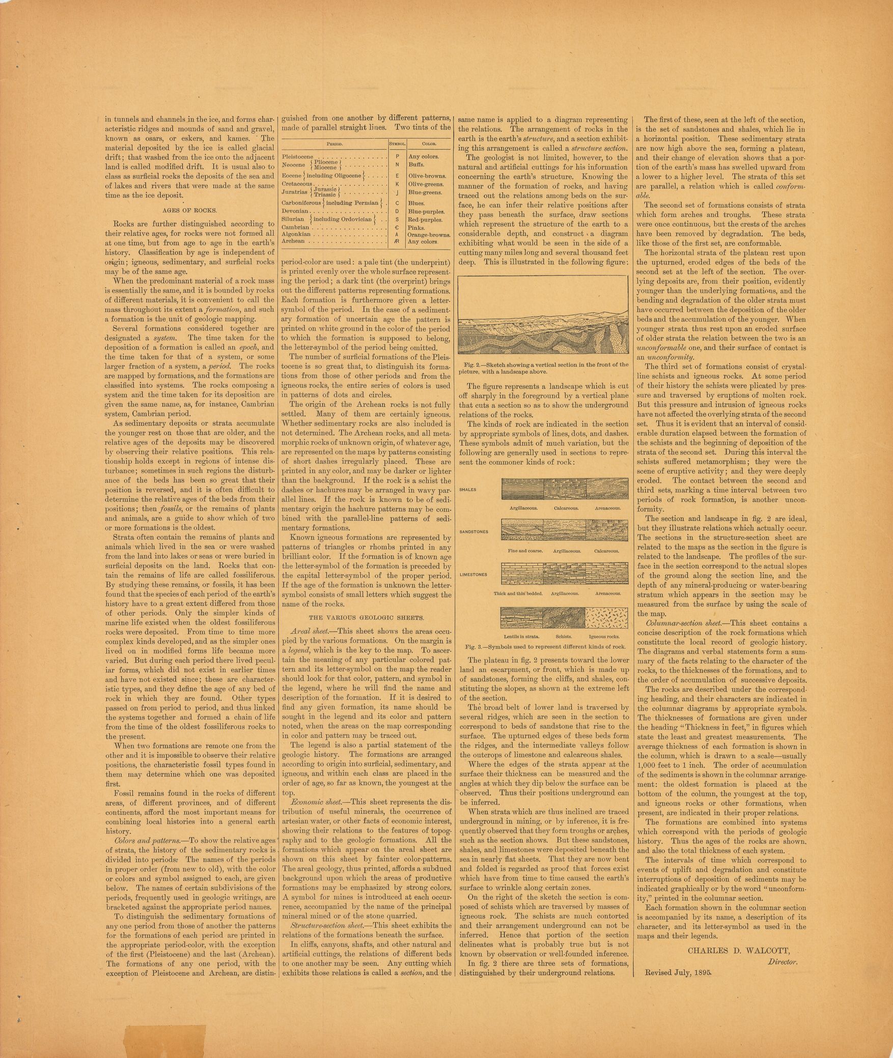
| dc.coverage.spatial | Tennessee | en |
| dc.creator | Hayes, C. W. (Charles Willard), 1859-1916. | |
| dc.date.accessioned | 2006-04-04T15:23:57Z | |
| dc.date.accessioned | 2012-06-02T07:04:27Z | |
| dc.date.available | 2006-04-04T15:23:57Z | |
| dc.date.available | 2012-06-02T07:04:27Z | |
| dc.date.issued | 1895 | |
| dc.identifier.govdoc | I19.5/1:22 | |
| dc.identifier.uri | https://hdl.handle.net/1969.1/3024 | |
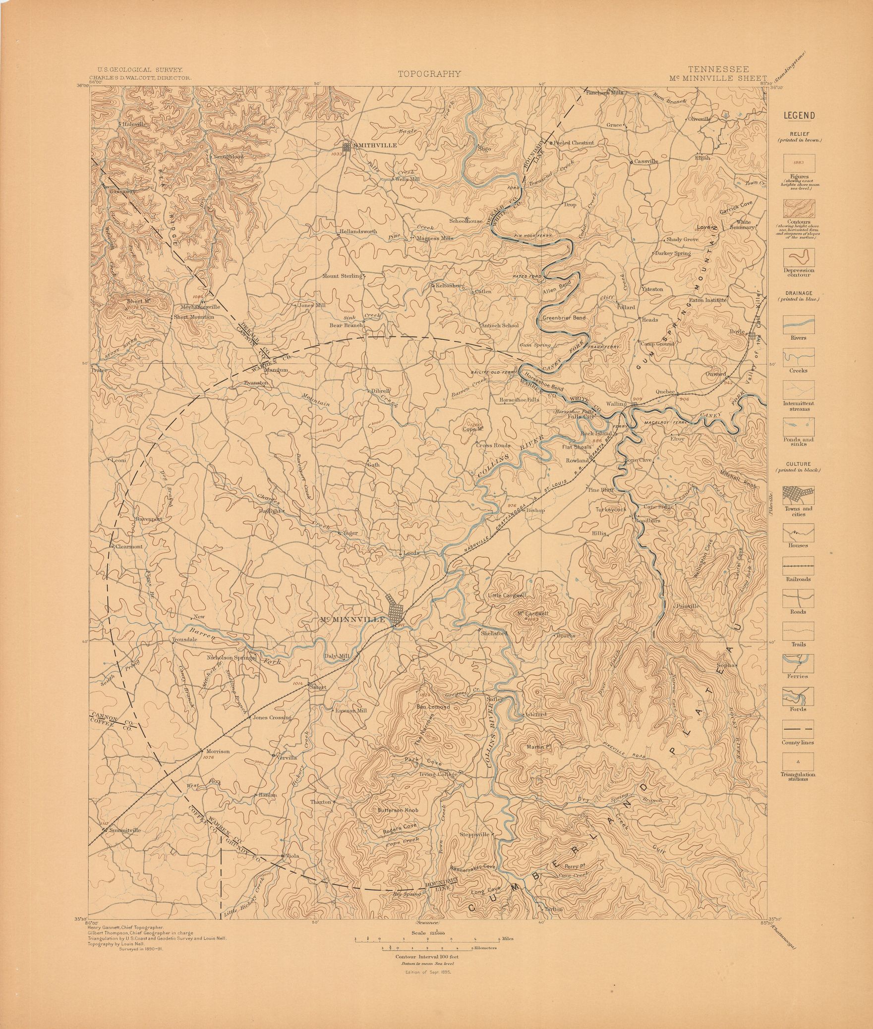
| dc.description | McMinnville folio, Tennessee | en |
| dc.format.extent | 107440604 bytes | en |
| dc.format.extent | 106677820 bytes | en |
| dc.format.extent | 106935540 bytes | en |
| dc.format.extent | 107374348 bytes | en |
| dc.format.extent | 105849032 bytes | en |
| dc.format.extent | 99148288 bytes | en |
| dc.format.extent | 107185008 bytes | en |
| dc.format.extent | 107403404 bytes | en |
| dc.format.extent | 106530568 bytes | en |
| dc.format.extent | 106815824 bytes | en |
| dc.format.extent | 55440253 bytes | en |
| dc.format.mimetype | image/tiff | |
| dc.format.mimetype | image/tiff | |
| dc.format.mimetype | image/tiff | |
| dc.format.mimetype | image/tiff | |
| dc.format.mimetype | application/pdf | |
| dc.format.mimetype | image/tiff | |
| dc.format.mimetype | image/tiff | |
| dc.format.mimetype | image/tiff | |
| dc.format.mimetype | image/tiff | |
| dc.format.mimetype | image/tiff | |
| dc.format.mimetype | image/tiff | |
| dc.language.iso | en_US | |
| dc.publisher | Geological Survey (United States) | |
| dc.relation.ispartofseries | Geologic Atlas of the United States | |
| dc.relation.ispartofseries | 22 | |
| dc.rights | No copyright; for more information see: https://rightsstatements.org/page/NoC-US/1.0/ | en |
| dc.rights.uri | https://rightsstatements.org/page/NoC-US/1.0/ | |
| dc.subject | Silurian - Chickamauga limestone | en |
| dc.subject | Carboniferous - Walden sandstone; Lookout sandstone; Bangor sandstone; Fort Payne chert | en |
| dc.subject | Devonian - Chattanooga black shale | en |
| dc.subject.lcsh | Geology -- United States --Maps | en |
| dc.subject.lcsh | Geology--Tennessee--Maps | en |
| dc.title | McMinnville folio, Tennessee | en |
| dc.type | Map | en |
| dc.type | Book | en |
| dc.type | Image | en |
| dc.coverage.box | northlimit=36; westlimit=-86; southlimit=35.5; eastlimit=-85.5 | en |
| dc.coverage.point | 35:30:00N85:30:00W | en |