| dc.coverage.spatial | Virginia | en |
| dc.coverage.spatial | West Virginia | en |
| dc.creator | Darton, Nelson Horatio, 1865-1948. | |
| dc.date.accessioned | 2006-03-31T20:42:08Z | |
| dc.date.accessioned | 2012-06-02T06:57:56Z | |
| dc.date.available | 2006-03-31T20:42:08Z | |
| dc.date.available | 2012-06-02T06:57:56Z | |
| dc.date.issued | 1894 | |
| dc.identifier.govdoc | I19.5/1:14 | |
| dc.identifier.uri | https://hdl.handle.net/1969.1/3014 | |
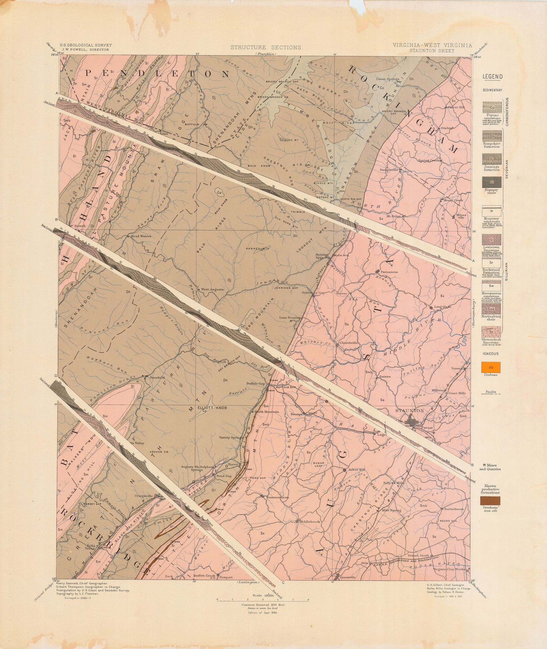
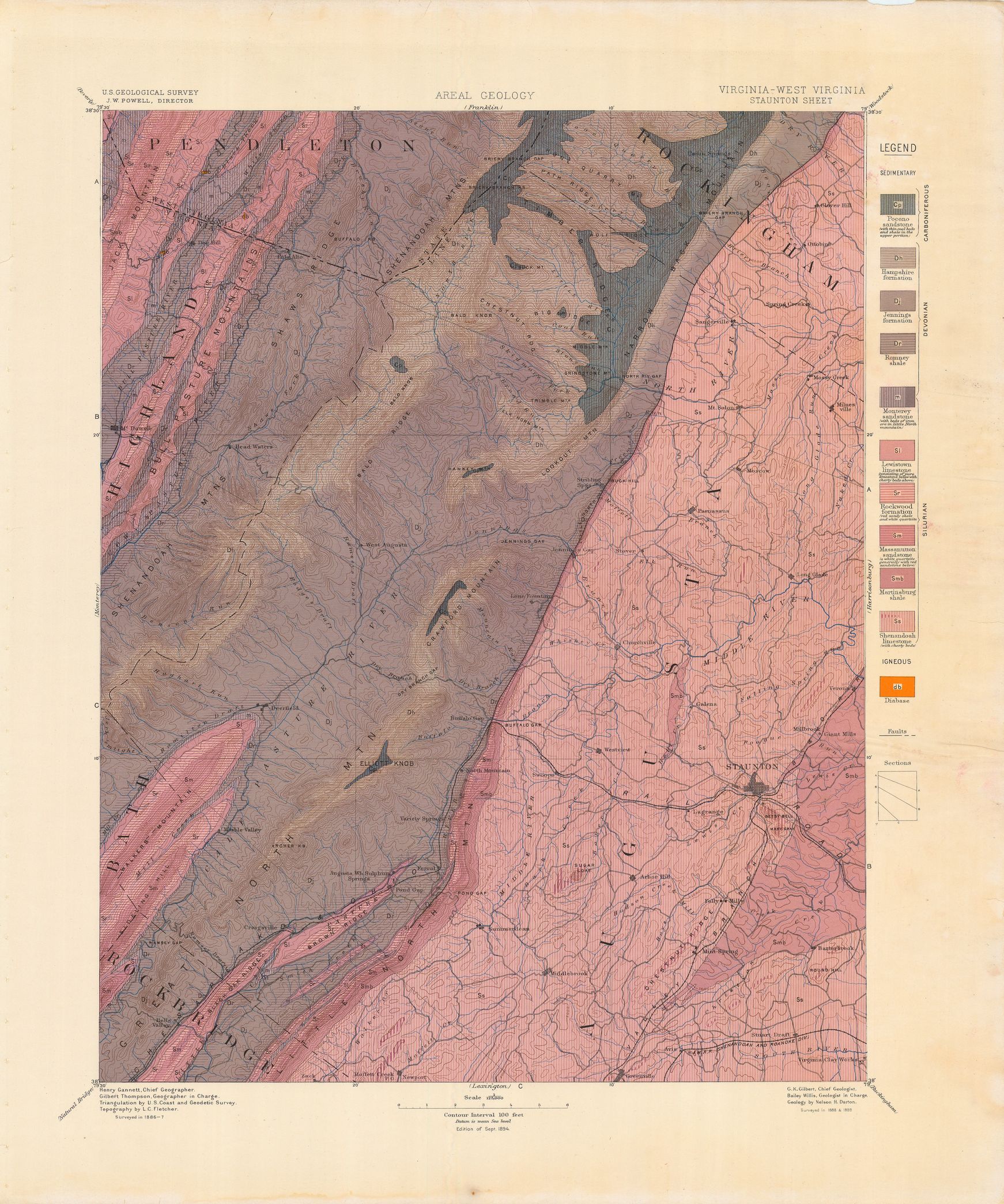
| dc.description | Staunton folio, Virginia-West Virginia | en |
| dc.format.extent | 106844924 bytes | en |
| dc.format.extent | 105337492 bytes | en |
| dc.format.extent | 104728052 bytes | en |
| dc.format.extent | 107107192 bytes | en |
| dc.format.extent | 105769640 bytes | en |
| dc.format.extent | 106820232 bytes | en |
| dc.format.extent | 108255904 bytes | en |
| dc.format.extent | 106860816 bytes | en |
| dc.format.extent | 105055852 bytes | en |
| dc.format.extent | 63165010 bytes | en |
| dc.format.extent | 107406536 bytes | en |
| dc.format.extent | 106569296 bytes | en |
| dc.format.mimetype | image/tiff | |
| dc.format.mimetype | image/tiff | |
| dc.format.mimetype | image/tiff | |
| dc.format.mimetype | image/tiff | |
| dc.format.mimetype | image/tiff | |
| dc.format.mimetype | application/pdf | |
| dc.format.mimetype | image/tiff | |
| dc.format.mimetype | image/tiff | |
| dc.format.mimetype | image/tiff | |
| dc.format.mimetype | image/tiff | |
| dc.format.mimetype | image/tiff | |
| dc.format.mimetype | image/tiff | |
| dc.language.iso | en_US | |
| dc.publisher | Geological Survey (United States) | |
| dc.relation.ispartofseries | Geologic Atlas of the United States | |
| dc.relation.ispartofseries | 14 | |
| dc.rights | No copyright; for more information see: https://rightsstatements.org/page/NoC-US/1.0/ | en |
| dc.rights.uri | https://rightsstatements.org/page/NoC-US/1.0/ | |
| dc.subject | Silurian - Monterey sandstone; Lewistown limestone; Rockwood formation; Massanuuon sandstone; Martinsburg shale; Shenandoa limestone | en |
| dc.subject | Devonian - Hampshire formation; Jennings formation; Romney shale; Monterey sandstone | en |
| dc.subject | Carboniferous - Pocono sandstone | en |
| dc.subject.lcsh | Geology--Virginia--Maps | en |
| dc.subject.lcsh | Geology--West Virginia--Pendleton County--Maps | en |
| dc.subject.lcsh | Geology -- United States --Maps | en |
| dc.title | Staunton folio, Virginia-West Virginia | en |
| dc.type | Map | en |
| dc.type | Image | en |
| dc.type | Book | en |
| dc.coverage.box | northlimit=38.5; westlimit=-79.5; southlimit=38; eastlimit=-79 | en |
| dc.coverage.point | 38:00:00N79:00:00W | en |