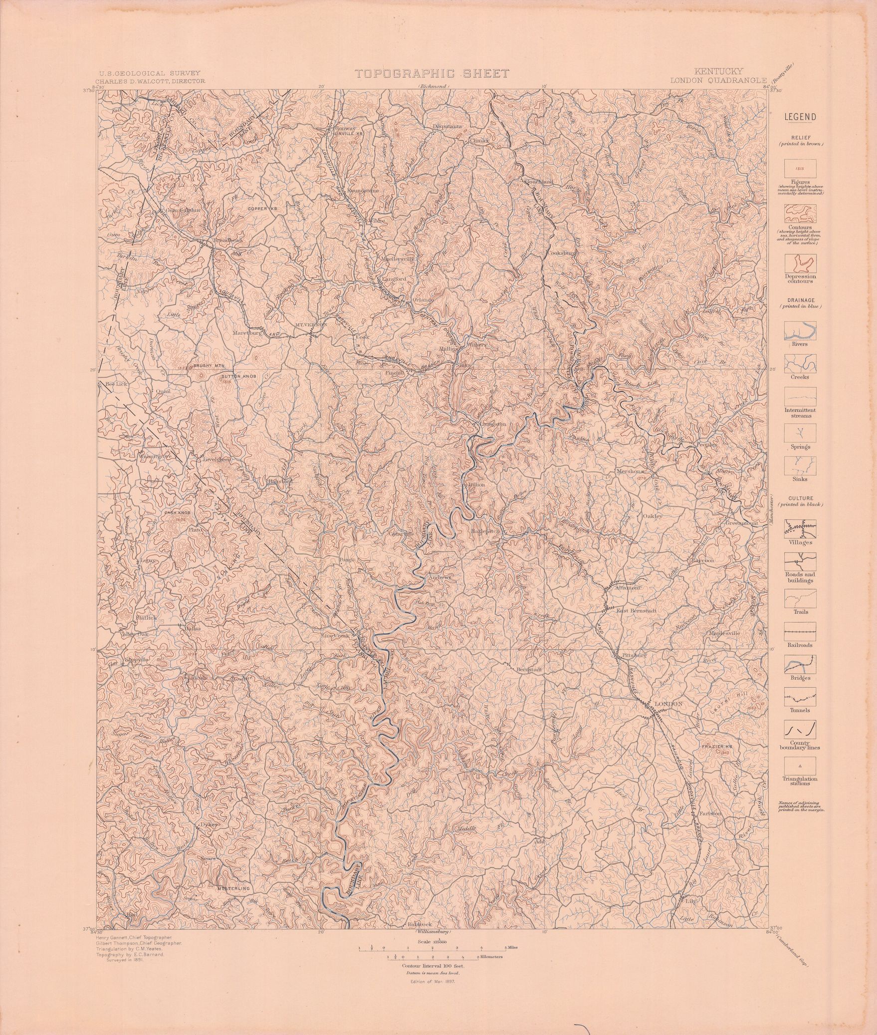
| dc.coverage.spatial | Kentucky | en |
| dc.creator | Campbell, Marius R. (Marius Robinson), 1858-1940. | |
| dc.date.accessioned | 2005-12-12T18:35:42Z | |
| dc.date.accessioned | 2012-06-01T21:48:53Z | |
| dc.date.available | 2005-12-12T18:35:42Z | |
| dc.date.available | 2012-06-01T21:48:53Z | |
| dc.date.issued | 1898 | |
| dc.identifier.govdoc | I19.5/1:47 | |
| dc.identifier.uri | https://hdl.handle.net/1969.1/2822 | |
| dc.description | London folio, Kentucky | en |
| dc.format.extent | 107804832 bytes | en |
| dc.format.extent | 106802596 bytes | en |
| dc.format.extent | 16954231 bytes | en |
| dc.format.extent | 107551648 bytes | en |
| dc.format.extent | 108171860 bytes | en |
| dc.format.extent | 108085544 bytes | en |
| dc.format.extent | 105583508 bytes | en |
| dc.format.extent | 107134872 bytes | en |
| dc.format.extent | 107172436 bytes | en |
| dc.format.extent | 107681488 bytes | en |
| dc.format.extent | 107398728 bytes | en |
| dc.format.extent | 107769772 bytes | en |
| dc.format.mimetype | image/tiff | |
| dc.format.mimetype | image/tiff | |
| dc.format.mimetype | image/tiff | |
| dc.format.mimetype | image/tiff | |
| dc.format.mimetype | image/tiff | |
| dc.format.mimetype | image/tiff | |
| dc.format.mimetype | image/tiff | |
| dc.format.mimetype | image/tiff | |
| dc.format.mimetype | image/tiff | |
| dc.format.mimetype | image/tiff | |
| dc.format.mimetype | image/tiff | |
| dc.format.mimetype | application/pdf | |
| dc.language.iso | en_US | |
| dc.publisher | Geological Survey (United States) | |
| dc.relation.ispartofseries | Geologic Atlas of the United States | |
| dc.relation.ispartofseries | 47 | |
| dc.rights | No copyright; for more information see: https://rightsstatements.org/page/NoC-US/1.0/ | en |
| dc.rights.uri | https://rightsstatements.org/page/NoC-US/1.0/ | |
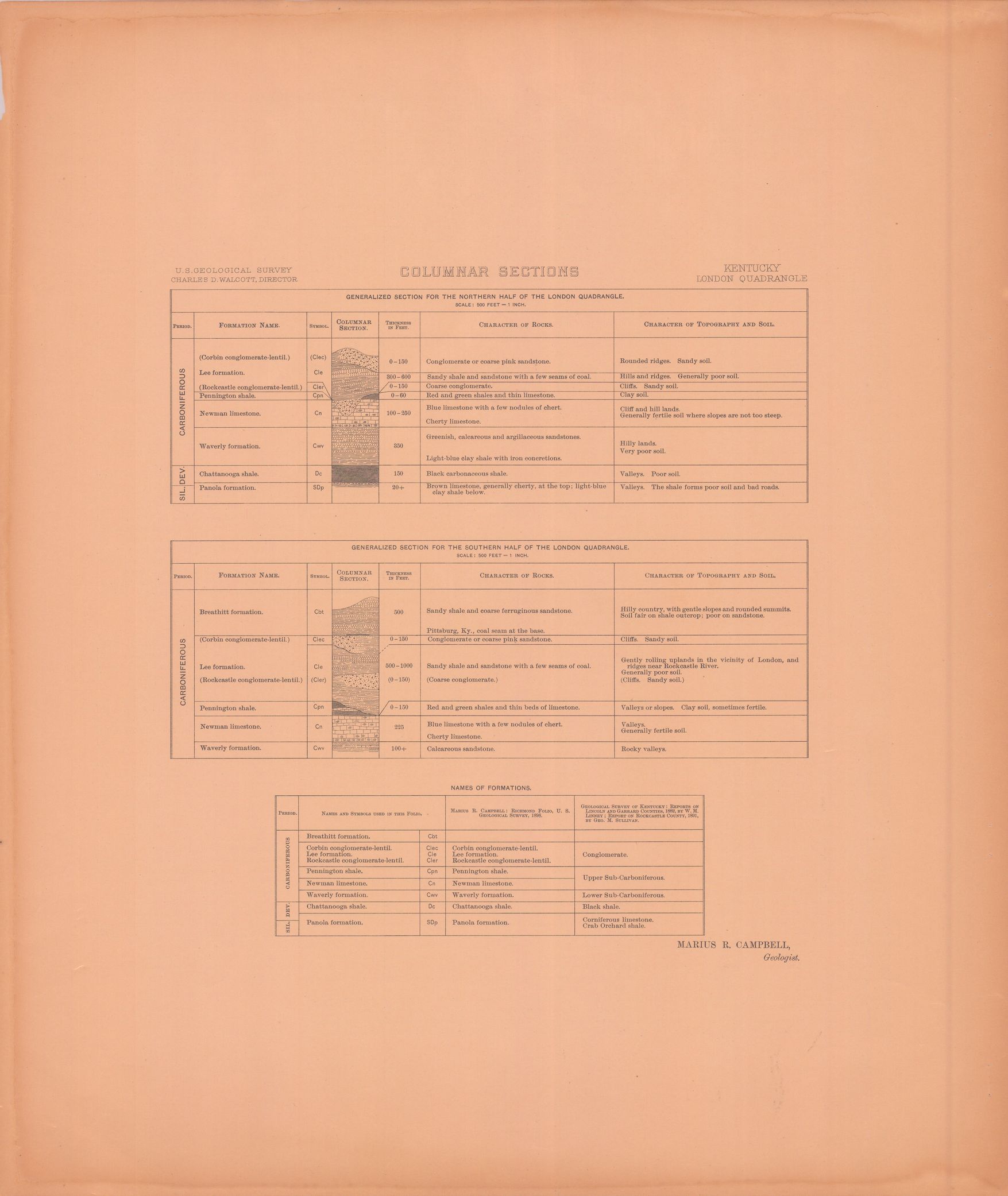
| dc.subject | Carboniferous - Breathitt formation; Lee formation; Corbin conglomerate-lentil; Rockcastle conglomerate-lentil; Pennington shale; Newman limestone; Waverly formation | en |
| dc.subject | Devonian - Chattanooga shale; Panola formation | en |
| dc.subject | Silurian - Panola formation | en |
| dc.subject.lcsh | Geology -- United States --Maps | en |
| dc.subject.lcsh | Geology--Kentucky--Maps | en |
| dc.title | London folio, Kentucky | en |
| dc.type | Image | en |
| dc.type | Map | en |
| dc.type | Book | en |
| dc.coverage.box | northlimit=37.5; westlimit=-84.5; southlimit=37; eastlimit=-84 | en |
| dc.coverage.point | 37:00:00N84:00:00W | en |