| dc.coverage.spatial | Kentucky | en |
| dc.creator | Campbell, Marius R. (Marius Robinson), 1858-1940. | |
| dc.date.accessioned | 2005-12-12T18:08:01Z | |
| dc.date.accessioned | 2012-06-01T21:58:57Z | |
| dc.date.available | 2005-12-12T18:08:01Z | |
| dc.date.available | 2012-06-01T21:58:57Z | |
| dc.date.issued | 1898 | |
| dc.identifier.govdoc | I19.5/1:46 | |
| dc.identifier.uri | https://hdl.handle.net/1969.1/2821 | |
| dc.description | Richmond folio, Kentucky | en |
| dc.format.extent | 108265704 bytes | en |
| dc.format.extent | 108475892 bytes | en |
| dc.format.extent | 17706204 bytes | en |
| dc.format.extent | 107375884 bytes | en |
| dc.format.extent | 108349716 bytes | en |
| dc.format.extent | 107718624 bytes | en |
| dc.format.extent | 107814332 bytes | en |
| dc.format.extent | 108188332 bytes | en |
| dc.format.extent | 106939716 bytes | en |
| dc.format.extent | 108205012 bytes | en |
| dc.format.extent | 107496564 bytes | en |
| dc.format.extent | 108490568 bytes | en |
| dc.format.mimetype | image/tiff | |
| dc.format.mimetype | image/tiff | |
| dc.format.mimetype | image/tiff | |
| dc.format.mimetype | image/tiff | |
| dc.format.mimetype | image/tiff | |
| dc.format.mimetype | image/tiff | |
| dc.format.mimetype | image/tiff | |
| dc.format.mimetype | image/tiff | |
| dc.format.mimetype | image/tiff | |
| dc.format.mimetype | image/tiff | |
| dc.format.mimetype | image/tiff | |
| dc.format.mimetype | application/pdf | |
| dc.language.iso | en_US | |
| dc.publisher | Geological Survey (United States) | |
| dc.relation.ispartofseries | Geologic Atlas of the United States | |
| dc.relation.ispartofseries | 46 | |
| dc.rights | No copyright; for more information see: https://rightsstatements.org/page/NoC-US/1.0/ | en |
| dc.rights.uri | https://rightsstatements.org/page/NoC-US/1.0/ | |
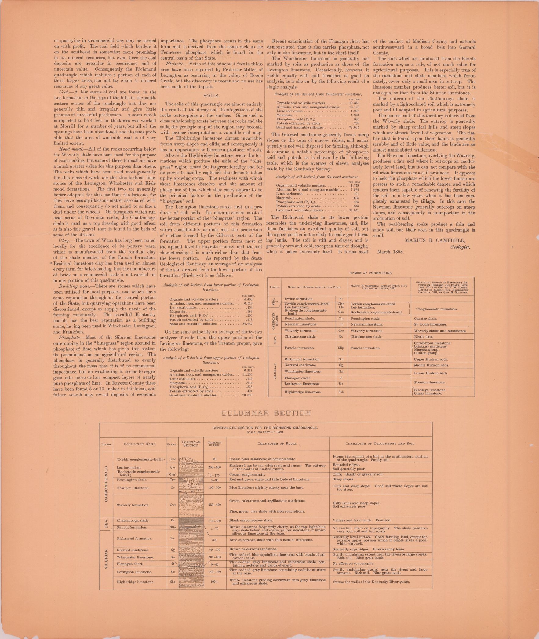
| dc.subject | Carboniferous - Lee conglomeration; Corbin conglomerate-lentil; Rockcastle conglomerate-lentil; Pennington shale; Newman limestone; Waverly formation | en |
| dc.subject | Silurian - Panola formation; Richmond formation; Garrard sandstone; Winchster limestone; Flanagan chert; Lexington limestone; Highbridge limestone | en |
| dc.subject | Devonian - Chattanooga shale; Panola formation | en |
| dc.subject | Neogene - Irvine formation | en |
| dc.subject.lcsh | Geology -- United States --Maps | en |
| dc.subject.lcsh | Geology--Kentucky--Maps | en |
| dc.title | Richmond folio, Kentucky | en |
| dc.type | Book | en |
| dc.type | Image | en |
| dc.type | Map | en |
| dc.coverage.box | northlimit=38; westlimit=-84.5; southlimit=37.5; eastlimit=-84 | en |
| dc.coverage.point | 37:30:00N84:00:00W | en |