Aerial Images of Veterinary College and Surrounding Areas, number 69
View/
Metadata
Show full item recordDescription
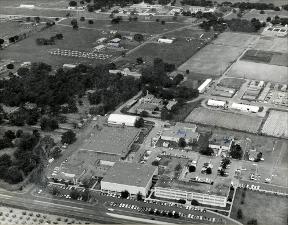
This is an image taken from an airplane with a view of the lands located to the west of the Main Campus. The Veterinary Medicine Education Complex is visible along University Drive (Highway 60). This picture was taken some time after the completion of the Veterinary Medicine Diagnostic Laboratory. At this time the Small Animal Hospital and Clinic had not started the construction of a new addition that added a new Clinic entrance to the left of the old clinic. Someone has labeled the Research Farm, Diagnostic Lab and the Vivarium III with ink. Physical description: black-and -white print (photograph), Mounted & Laminated: 27.5X34mmSubject
Aerial photographySchool lands
Campus planning
Education parks
Buildings
Hospitals, Animal
Education
Schools, Veterinary
Citation
Aerial Images of Veterinary College and Surrounding Areas, number 69. Available electronically from https : / /hdl .handle .net /1969 .1 /170880.