Aerial Images of Veterinary College and Surrounding Areas, number 42
View/
Metadata
Show full item recordDescription
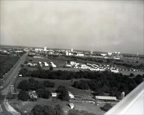
This is an image taken from an airplane with a view of the lands located to the west of the Main Campus and look off in the distance the Main side of Campus can be viewed, with Kyle field in the right background. Highway 60 or University Drive is shown on the left and the metal framework can be seen for the construction of the Health Sciences Center, Reynolds building. Physical description: black-and-white negatives, 6X6.5mm negative with proofSubject
Aerial photographySchool lands
Campus planning
Education parks
Buildings
Hospitals, Animal
Education
Schools, Medical
Schools, Veterinary
Citation
Aerial Images of Veterinary College and Surrounding Areas, number 42. Available electronically from https : / /hdl .handle .net /1969 .1 /170850.