| dc.coverage.spatial | Cuba | en |
| dc.creator | United States. Army. Engineer Reproduction Plant. | |
| dc.date.accessioned | 2012-02-28T19:56:58Z | |
| dc.date.available | 2012-02-28T19:56:58Z | |
| dc.date.issued | 1933 | |
| dc.identifier.other | 2013855 | |
| dc.identifier.uri | https://hdl.handle.net/1969.1/128942 | |
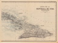
| dc.description | Railroads are indicated as broad or narrow gauge | en |
| dc.description | three classes of roads and telecommunication facilities are shown. | en |
| dc.language.iso | spa | |
| dc.publisher | Engineer Reproduction Plant, U.S. Army | |
| dc.rights | No Copyright - United States | en |
| dc.rights.uri | http://rightsstatements.org/vocab/NoC-US/1.0/ | |
| dc.subject.lcc | G4920 1933 .U6 | en |
| dc.subject.lcsh | Cuba --Maps, Topographic | en |
| dc.title | Carta de la república de Cuba | en |
| dc.type | Map | en |
| dc.coverage.box | northlimit=23.59; westlimit=-85.44; southlimit=19.44; eastlimit=-73.64 | en |