Search
Now showing items 1-3 of 3
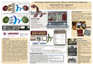
Providing a Spatial Context for Library and Archival Collections: Mapping Historic Aggieland
(2014-05-17)
Libraries and archives have large collections of historic maps and photos. Creative digital exhibits allow users a unique framework to these collections, with mapping platforms providing a spatial context to collections ...
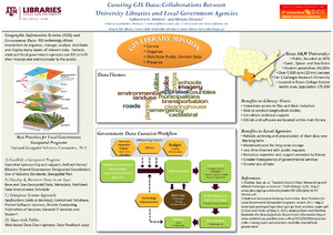
Curating GIS Data: Collaborations Between University Libraries and Local Government Agencies
(9th International Data Curation Conference, 2014-02-25)
GIS Day(s) Palooza Extravaganza 2013
(2014-10-22)
A summary of the Texas A & M University GIS Day 2013 outreach and instruction events, presented to TAMU Libraries staff.