| dc.coverage.spatial | Virginia | en |
| dc.coverage.spatial | West Virginia | en |
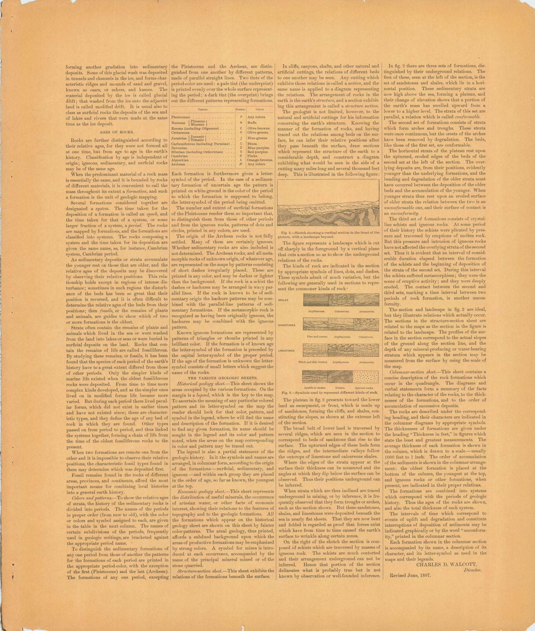
| dc.creator | Campbell, Marius R. (Marius Robinson), 1858-1940. | |
| dc.date.accessioned | 2006-04-04T19:22:48Z | |
| dc.date.accessioned | 2012-06-02T06:38:52Z | |
| dc.date.available | 2006-04-04T19:22:48Z | |
| dc.date.available | 2012-06-02T06:38:52Z | |
| dc.date.issued | 1896 | |
| dc.identifier.govdoc | I19.5/1:26 | |
| dc.identifier.uri | https://hdl.handle.net/1969.1/3027 | |
| dc.description | Pocahontas folio, Virginia-West Virginia | en |
| dc.format.extent | 106576752 bytes | en |
| dc.format.extent | 106597124 bytes | en |
| dc.format.extent | 106829564 bytes | en |
| dc.format.extent | 107542172 bytes | en |
| dc.format.extent | 105550924 bytes | en |
| dc.format.extent | 105552060 bytes | en |
| dc.format.extent | 104073420 bytes | en |
| dc.format.extent | 106592284 bytes | en |
| dc.format.extent | 107008228 bytes | en |
| dc.format.extent | 108107348 bytes | en |
| dc.format.extent | 107842924 bytes | en |
| dc.format.extent | 78436455 bytes | en |
| dc.format.extent | 103126756 bytes | en |
| dc.format.extent | 106972456 bytes | en |
| dc.format.extent | 107383680 bytes | en |
| dc.format.mimetype | image/tiff | |
| dc.format.mimetype | image/tiff | |
| dc.format.mimetype | image/tiff | |
| dc.format.mimetype | application/pdf | |
| dc.format.mimetype | image/tiff | |
| dc.format.mimetype | image/tiff | |
| dc.format.mimetype | image/tiff | |
| dc.format.mimetype | image/tiff | |
| dc.format.mimetype | image/tiff | |
| dc.format.mimetype | image/tiff | |
| dc.format.mimetype | image/tiff | |
| dc.format.mimetype | image/tiff | |
| dc.format.mimetype | image/tiff | |
| dc.format.mimetype | image/tiff | |
| dc.format.mimetype | image/tiff | |
| dc.language.iso | en_US | |
| dc.publisher | Geological Survey (United States) | |
| dc.relation.ispartofseries | Geologic Atlas of the United States | |
| dc.relation.ispartofseries | 26 | |
| dc.rights | No copyright; for more information see: https://rightsstatements.org/page/NoC-US/1.0/ | en |
| dc.rights.uri | https://rightsstatements.org/page/NoC-US/1.0/ | |
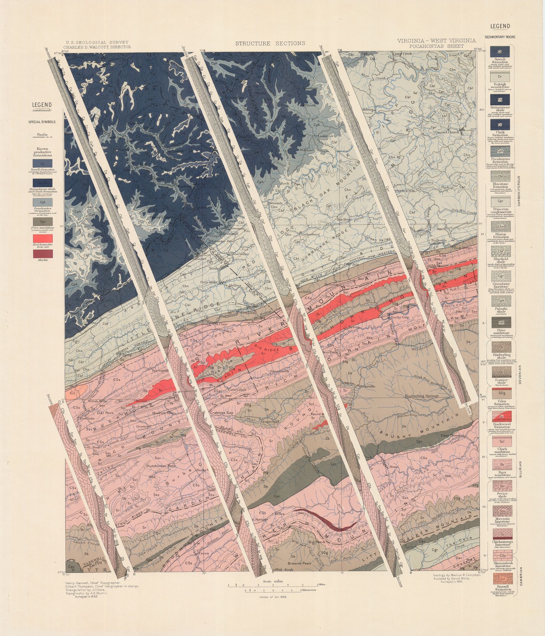
| dc.subject | Carboniferous - Sewell formation; Raleigh sandstone; Quinnimont shale; Clark formation; Pocahontas formation; Bluestone formation; Princeton conglomerate; Hinton foramtion; Bluefield shale; Greenbrier limestone; Pulaski shale; Price sandstone | en |
| dc.subject | Devonian - Kimberling shale; Romney shale; Giles formation; Rockwood formation; Clinch sandstone; Bays sandstone; Sevier shale; Moccasin limestone; Chickamauga limestone; Shenandoah limestone | en |
| dc.subject | Silurian - - Kimberling shale; Romney shale; Giles formation; Rockwood formation; Clinch sandstone; Bays sandstone; Sevier shale; Moccasin limestone; Chickamauga limestone; Shenandoah limestone | en |
| dc.subject | Cambrian - Shenandoah limestone; Russell formation | en |
| dc.subject.lcsh | Geology -- United States --Maps | en |
| dc.subject.lcsh | Geology--Virginia--Maps | en |
| dc.subject.lcsh | Geology--West Virginia--Maps | en |
| dc.title | Pocahontas folio, Virginia-West Virginia | en |
| dc.type | Book | en |
| dc.type | Image | en |
| dc.type | Map | en |
| dc.coverage.box | northlimit=37.5; westlimit=-81.5; southlimit=37; eastlimit=-81 | en |
| dc.coverage.point | 37:00:00N81:00:00W | en |