| dc.coverage.spatial | Oregon--Curry County | en |
| dc.coverage.spatial | Oregon--Coos County | en |
| dc.creator | Diller, J. S. (Joseph Silas), b. 1850. | |
| dc.date.accessioned | 2006-02-14T20:45:35Z | |
| dc.date.accessioned | 2012-06-02T05:53:10Z | |
| dc.date.available | 2006-02-14T20:45:35Z | |
| dc.date.available | 2012-06-02T05:53:10Z | |
| dc.date.issued | 1903 | |
| dc.identifier.govdoc | I19.5/1:89 | |
| dc.identifier.uri | https://hdl.handle.net/1969.1/2929 | |
| dc.description | Port Oxford folio, Oregon | en |
| dc.format.extent | 23280311 bytes | en |
| dc.format.extent | 106290928 bytes | en |
| dc.format.extent | 106679288 bytes | en |
| dc.format.extent | 106436980 bytes | en |
| dc.format.extent | 106331092 bytes | en |
| dc.format.extent | 106764076 bytes | en |
| dc.format.extent | 107852752 bytes | en |
| dc.format.extent | 106464380 bytes | en |
| dc.format.extent | 105311064 bytes | en |
| dc.format.extent | 104652068 bytes | en |
| dc.format.extent | 106220868 bytes | en |
| dc.format.extent | 105569508 bytes | en |
| dc.format.extent | 107429040 bytes | en |
| dc.format.extent | 106860460 bytes | en |
| dc.format.extent | 105279632 bytes | en |
| dc.format.mimetype | image/tiff | |
| dc.format.mimetype | image/tiff | |
| dc.format.mimetype | application/pdf | |
| dc.format.mimetype | image/tiff | |
| dc.format.mimetype | image/tiff | |
| dc.format.mimetype | image/tiff | |
| dc.format.mimetype | image/tiff | |
| dc.format.mimetype | image/tiff | |
| dc.format.mimetype | image/tiff | |
| dc.format.mimetype | image/tiff | |
| dc.format.mimetype | image/tiff | |
| dc.format.mimetype | image/tiff | |
| dc.format.mimetype | image/tiff | |
| dc.format.mimetype | image/tiff | |
| dc.format.mimetype | image/tiff | |
| dc.language.iso | en_US | |
| dc.publisher | Geological Survey (United States) | |
| dc.relation.ispartofseries | Geologic Atlas of the United States | |
| dc.relation.ispartofseries | 89 | |
| dc.rights | No copyright; for more information see: https://rightsstatements.org/page/NoC-US/1.0/ | en |
| dc.rights.uri | https://rightsstatements.org/page/NoC-US/1.0/ | |
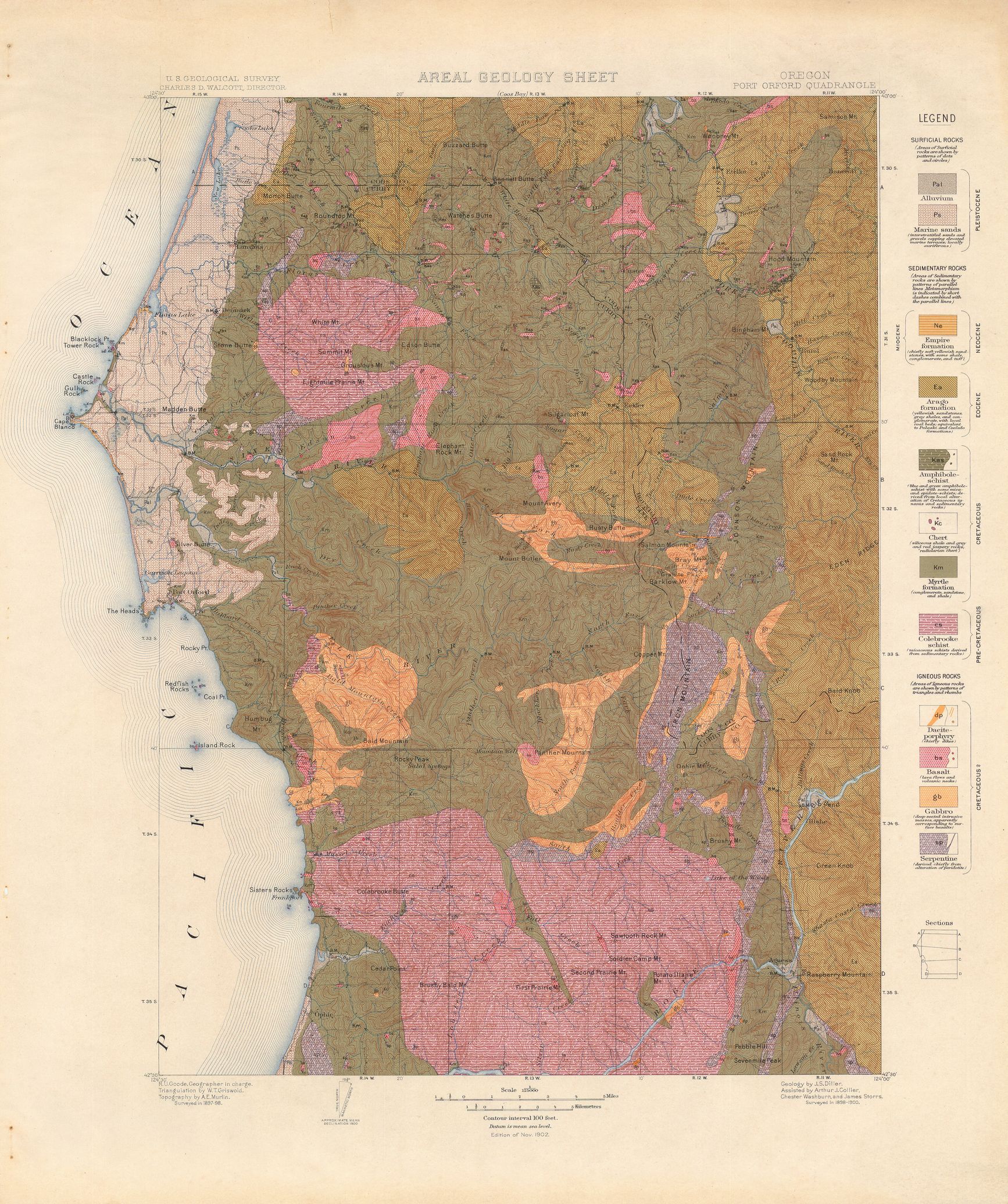
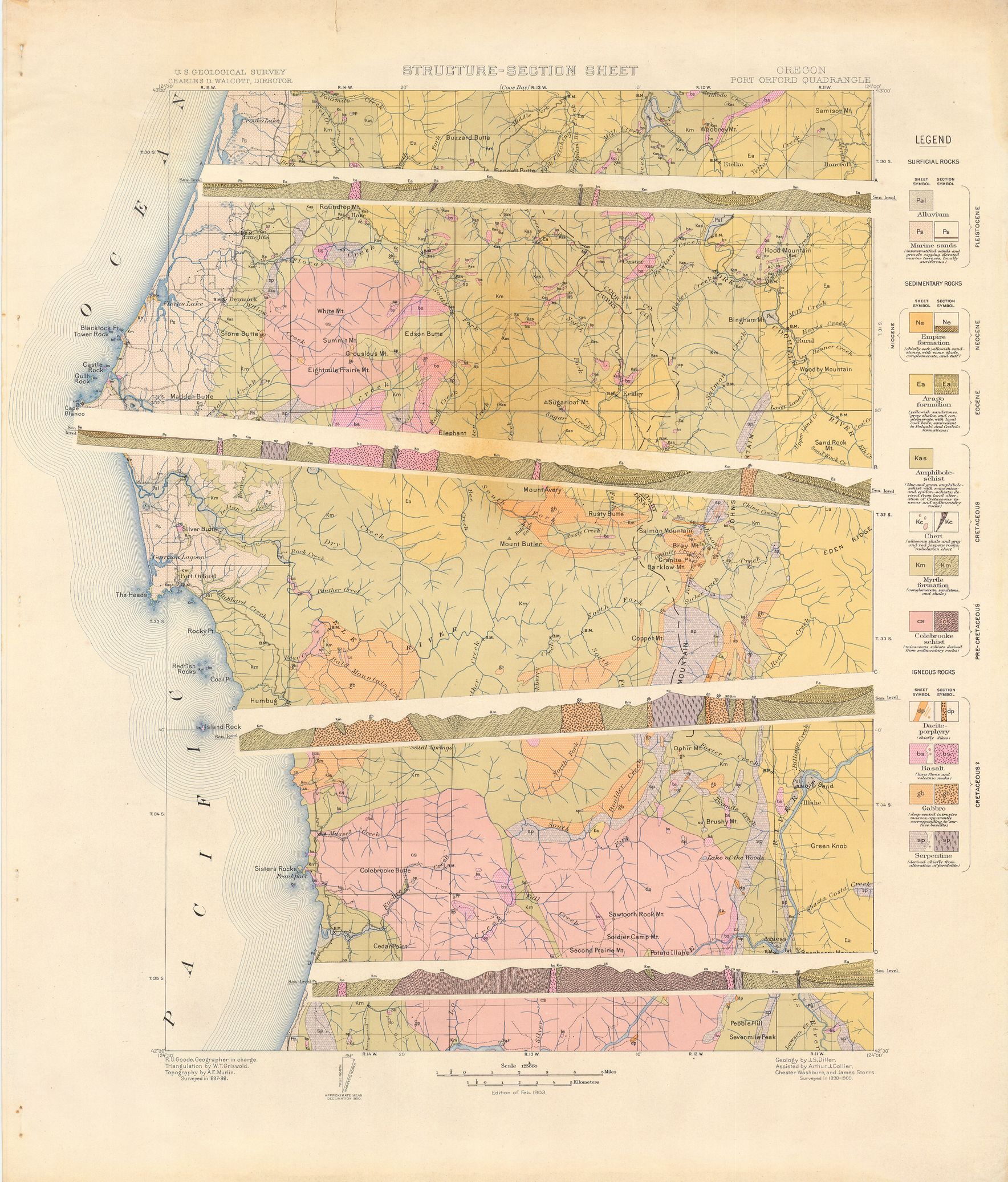
| dc.subject | Pre-Cretaceous - Colebrooke schist | en |
| dc.subject | Cretaceous - Myrtle formation | en |
| dc.subject | Paleogene - Arago formation | en |
| dc.subject | Neogene - Empire formation | en |
| dc.subject.lcsh | Geology -- United States --Maps | en |
| dc.subject.lcsh | Geology--Oregon--Coos County--Maps | en |
| dc.subject.lcsh | Geology--Oregon--Curry County--Maps | en |
| dc.title | Port Orford folio, Oregon. | en |
| dc.type | Map | en |
| dc.type | Image | en |
| dc.type | Book | en |
| dc.coverage.box | northlimit=43; westlimit=-124.5; southlimit=42.5; eastlimit=-124 | en |
| dc.coverage.point | 42:30:00N124:00:00W | en |