| dc.coverage.spatial | Nebraska | en |
| dc.creator | Darton, Nelson Horatio, 1865-1948. | |
| dc.date.accessioned | 2006-02-14T20:07:39Z | |
| dc.date.accessioned | 2012-06-01T19:49:49Z | |
| dc.date.available | 2006-02-14T20:07:39Z | |
| dc.date.available | 2012-06-01T19:49:49Z | |
| dc.date.issued | 1903 | |
| dc.identifier.govdoc | I19.5/1:87 | |
| dc.identifier.uri | https://hdl.handle.net/1969.1/2927 | |
| dc.description | Camp Clarke folio, Nebraska | en |
| dc.format.extent | 107035016 bytes | en |
| dc.format.extent | 107322876 bytes | en |
| dc.format.extent | 107417176 bytes | en |
| dc.format.extent | 106527928 bytes | en |
| dc.format.extent | 107552888 bytes | en |
| dc.format.extent | 106631640 bytes | en |
| dc.format.extent | 107511416 bytes | en |
| dc.format.extent | 107188856 bytes | en |
| dc.format.extent | 108467132 bytes | en |
| dc.format.extent | 107429440 bytes | en |
| dc.format.extent | 107765760 bytes | en |
| dc.format.extent | 107850180 bytes | en |
| dc.format.extent | 16050513 bytes | en |
| dc.format.mimetype | image/tiff | |
| dc.format.mimetype | image/tiff | |
| dc.format.mimetype | image/tiff | |
| dc.format.mimetype | image/tiff | |
| dc.format.mimetype | image/tiff | |
| dc.format.mimetype | image/tiff | |
| dc.format.mimetype | image/tiff | |
| dc.format.mimetype | image/tiff | |
| dc.format.mimetype | image/tiff | |
| dc.format.mimetype | image/tiff | |
| dc.format.mimetype | image/tiff | |
| dc.format.mimetype | image/tiff | |
| dc.format.mimetype | application/pdf | |
| dc.language.iso | en_US | |
| dc.publisher | Geological Survey (United States) | |
| dc.relation.ispartofseries | Geologic Atlas of the United States | |
| dc.relation.ispartofseries | 87 | |
| dc.rights | No copyright; for more information see: https://rightsstatements.org/page/NoC-US/1.0/ | en |
| dc.rights.uri | https://rightsstatements.org/page/NoC-US/1.0/ | |
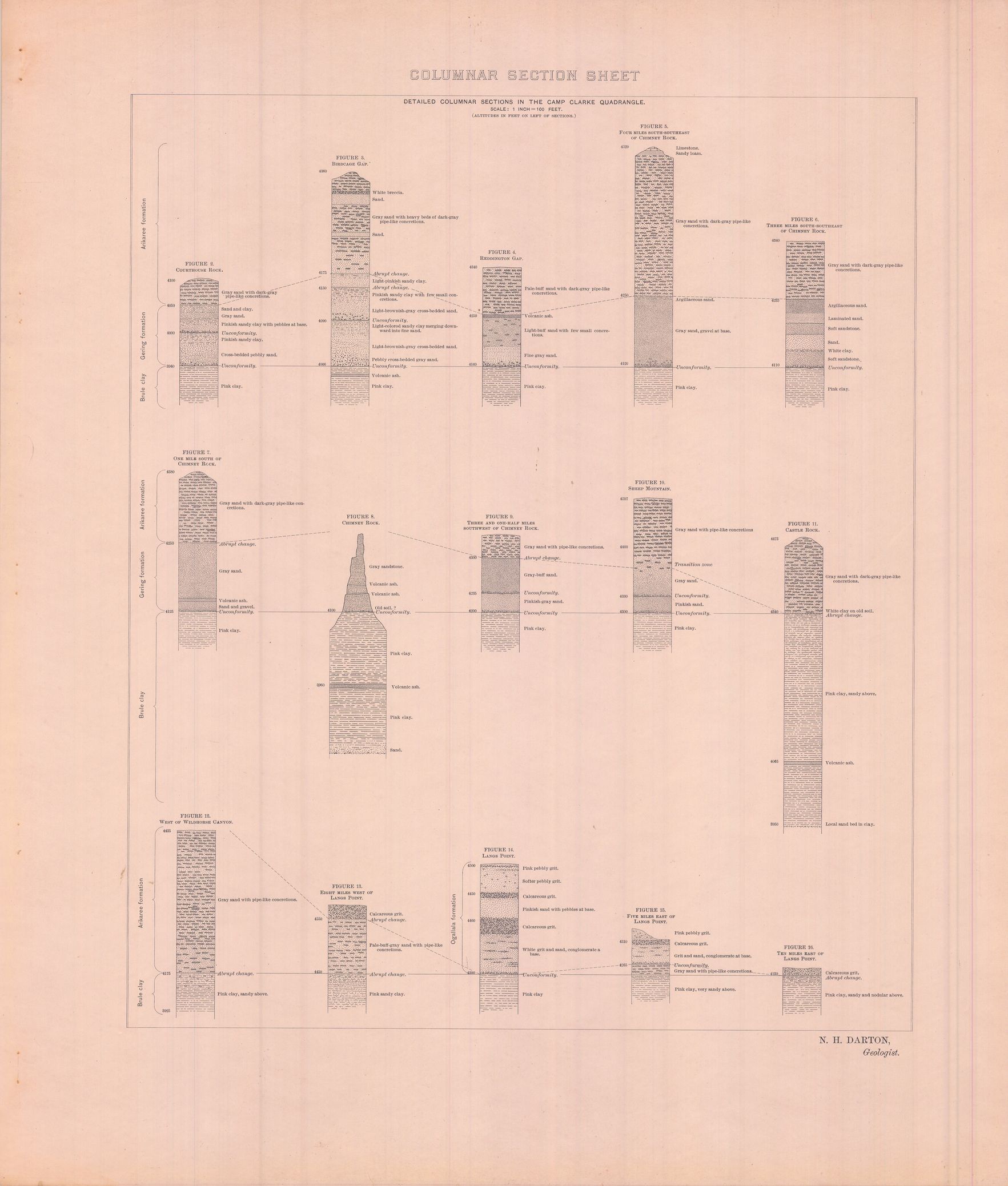
| dc.subject | Neogene - Ogallala formation; Arikaree formation; Gering formation | en |
| dc.subject | Paleogene - Brule clay | en |
| dc.subject.lcsh | Geology -- United States --Maps | en |
| dc.subject.lcsh | Geology--Nebraska--Maps | en |
| dc.title | Camp Clarke folio, Nebraska | en |
| dc.type | Book | en |
| dc.type | Image | en |
| dc.type | Map | en |
| dc.coverage.box | northlimit=42; westlimit=-103.5; southlimit=41.5; eastlimit=-103 | en |
| dc.coverage.point | 41:30:00N103:00:00W | en |