| dc.date.accessioned | 2012-09-27T16:44:19Z | |
| dc.date.available | 2012-09-27T16:44:19Z | |
| dc.date.issued | 1898 | |
| dc.identifier.uri | https://hdl.handle.net/1969.1/146840 | |
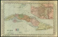
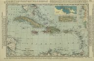
| dc.description | 3 views (cover, map of Cuba and map of West Indies) : color. ; on sheet 72 x 56 cm. fold. in cover 19 x 10 cm. | en |
| dc.language.iso | eng | |
| dc.publisher | Rand McNally and Company | |
| dc.rights | No Copyright - United States | en |
| dc.rights.uri | http://rightsstatements.org/vocab/NoC-US/1.0/ | |
| dc.subject.lcsh | World maps | en |
| dc.subject.lcsh | West Indies --Maps | en |
| dc.subject.lcsh | Cuba --Maps | en |
| dc.title | Official war maps: latest indexed map of the world, Cuba, Santo Domingo, Puerto Rico, West Indies, China and Philippine Islands, also other information of national interest | en |
| dc.type | Map | en |
| dc.rights.requestable | FALSE | en |