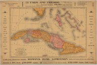
| dc.coverage.spatial | Cuba | en |
| dc.creator | Crowell Publishing Company | |
| dc.date.accessioned | 2012-02-28T19:47:25Z | |
| dc.date.available | 2012-02-28T19:47:25Z | |
| dc.date.issued | 1897 | |
| dc.identifier.other | 1198279 | |
| dc.identifier.uri | https://hdl.handle.net/1969.1/128915 | |
| dc.description | Relief shown by hachures. Depths shown by bathymetric isolines. | en |
| dc.description | 1 map (2 views showing front and back) | en |
| dc.language.iso | eng | |
| dc.publisher | Mast, Crowell & Kirkpatrick Publishers | |
| dc.rights | No Copyright - United States | en |
| dc.rights.uri | http://rightsstatements.org/vocab/NoC-US/1.0/ | |
| dc.subject.lcc | G4920 1897 .M3 | en |
| dc.subject.lcsh | Cuba --Maps | en |
| dc.title | Map of Cuba: its provinces, railroads, cities, towns, harbors, bays, etc. also southern Florida and neighboring islands of the West Indies | en |
| dc.type | Map | en |
| dc.coverage.box | northlimit=27.15; westlimit=-86.72; southlimit=18.12; eastlimit=-72.51 | en |