| dc.coverage.spatial | North Carolina | en |
| dc.coverage.spatial | Tennessee | en |
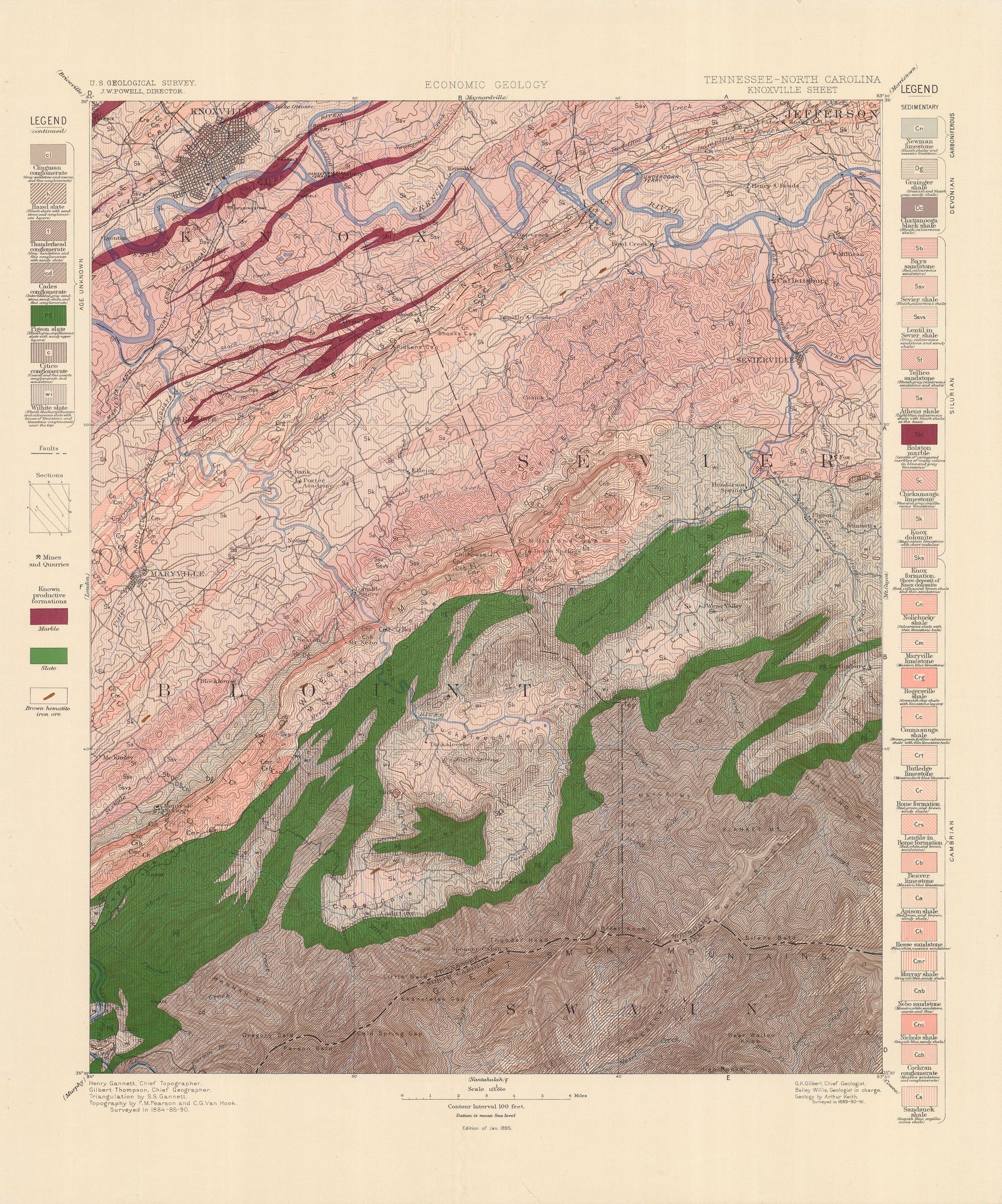
| dc.creator | Keith, Arthur. | |
| dc.date.accessioned | 2006-03-31T21:19:47Z | |
| dc.date.accessioned | 2012-06-02T06:52:17Z | |
| dc.date.available | 2006-03-31T21:19:47Z | |
| dc.date.available | 2012-06-02T06:52:17Z | |
| dc.date.issued | 1895 | |
| dc.identifier.govdoc | I19.5/1:16 | |
| dc.identifier.uri | https://hdl.handle.net/1969.1/3016 | |
| dc.description | Knoxville folio, Tennessee-North Carolina | en |
| dc.format.extent | 79165814 bytes | en |
| dc.format.extent | 106332212 bytes | en |
| dc.format.extent | 105333980 bytes | en |
| dc.format.extent | 106219136 bytes | en |
| dc.format.extent | 106014220 bytes | en |
| dc.format.extent | 106523816 bytes | en |
| dc.format.extent | 105869976 bytes | en |
| dc.format.extent | 106174784 bytes | en |
| dc.format.extent | 106150652 bytes | en |
| dc.format.extent | 107472072 bytes | en |
| dc.format.extent | 107066808 bytes | en |
| dc.format.extent | 105055752 bytes | en |
| dc.format.extent | 105443540 bytes | en |
| dc.format.extent | 105813308 bytes | en |
| dc.format.extent | 105428984 bytes | en |
| dc.format.mimetype | image/tiff | |
| dc.format.mimetype | image/tiff | |
| dc.format.mimetype | application/pdf | |
| dc.format.mimetype | image/tiff | |
| dc.format.mimetype | image/tiff | |
| dc.format.mimetype | image/tiff | |
| dc.format.mimetype | image/tiff | |
| dc.format.mimetype | image/tiff | |
| dc.format.mimetype | image/tiff | |
| dc.format.mimetype | image/tiff | |
| dc.format.mimetype | image/tiff | |
| dc.format.mimetype | image/tiff | |
| dc.format.mimetype | image/tiff | |
| dc.format.mimetype | image/tiff | |
| dc.format.mimetype | image/tiff | |
| dc.language.iso | en_US | |
| dc.publisher | Geological Survey (United States) | |
| dc.relation.ispartofseries | Geologic Atlas of the United States | |
| dc.relation.ispartofseries | 16 | |
| dc.rights | No copyright; for more information see: https://rightsstatements.org/page/NoC-US/1.0/ | en |
| dc.rights.uri | https://rightsstatements.org/page/NoC-US/1.0/ | |
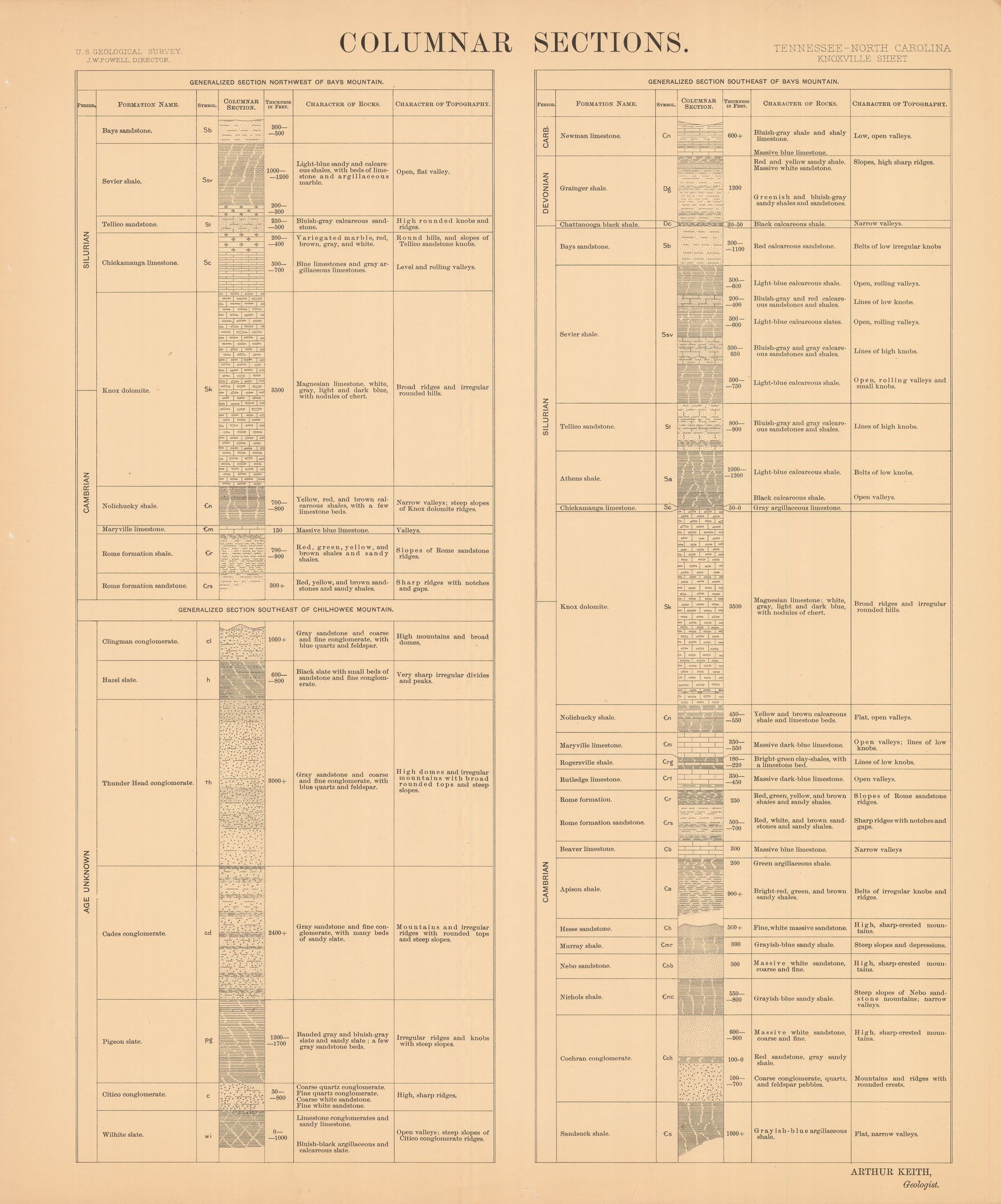
| dc.subject | Silurian - Bays sandstone; Sevier shale; Tellico sandstone; Athens shale; Holston Marble; Chickamanga limestone; Knox formation | en |
| dc.subject | Devonian - Grainger shale; Chattanooga black shale | en |
| dc.subject | Carboniferous - Newman limestone | en |
| dc.subject | Proterozoic - Clingman conglomerate; Hazel slate; Thunderhead conglomerate; Cades conglomerate; Pigeon slate; Citico conglomerate; Wilhite slate | en |
| dc.subject.lcsh | Geology -- United States --Maps | en |
| dc.subject.lcsh | Geology--North Carolina--Swain County--Maps | en |
| dc.subject.lcsh | Geology--Tennessee--Maps | en |
| dc.title | Knoxville folio, Tennessee-North Carolina | en |
| dc.type | Map | en |
| dc.type | Image | en |
| dc.type | Book | en |
| dc.coverage.box | northlimit=36; westlimit=-84; southlimit=35.5; eastlimit=-83.5 | en |
| dc.coverage.point | 35:30:00N83:30:00W | en |