| dc.coverage.spatial | Oklahoma | en |
| dc.creator | Taff, Joseph A. (Joseph Alexander), b. 1862. | |
| dc.date.accessioned | 2006-02-17T20:36:14Z | |
| dc.date.accessioned | 2012-06-01T23:43:32Z | |
| dc.date.available | 2006-02-17T20:36:14Z | |
| dc.date.available | 2012-06-01T23:43:32Z | |
| dc.date.issued | 1903 | |
| dc.identifier.govdoc | I19.5/1:98 | |
| dc.identifier.uri | https://hdl.handle.net/1969.1/2936 | |
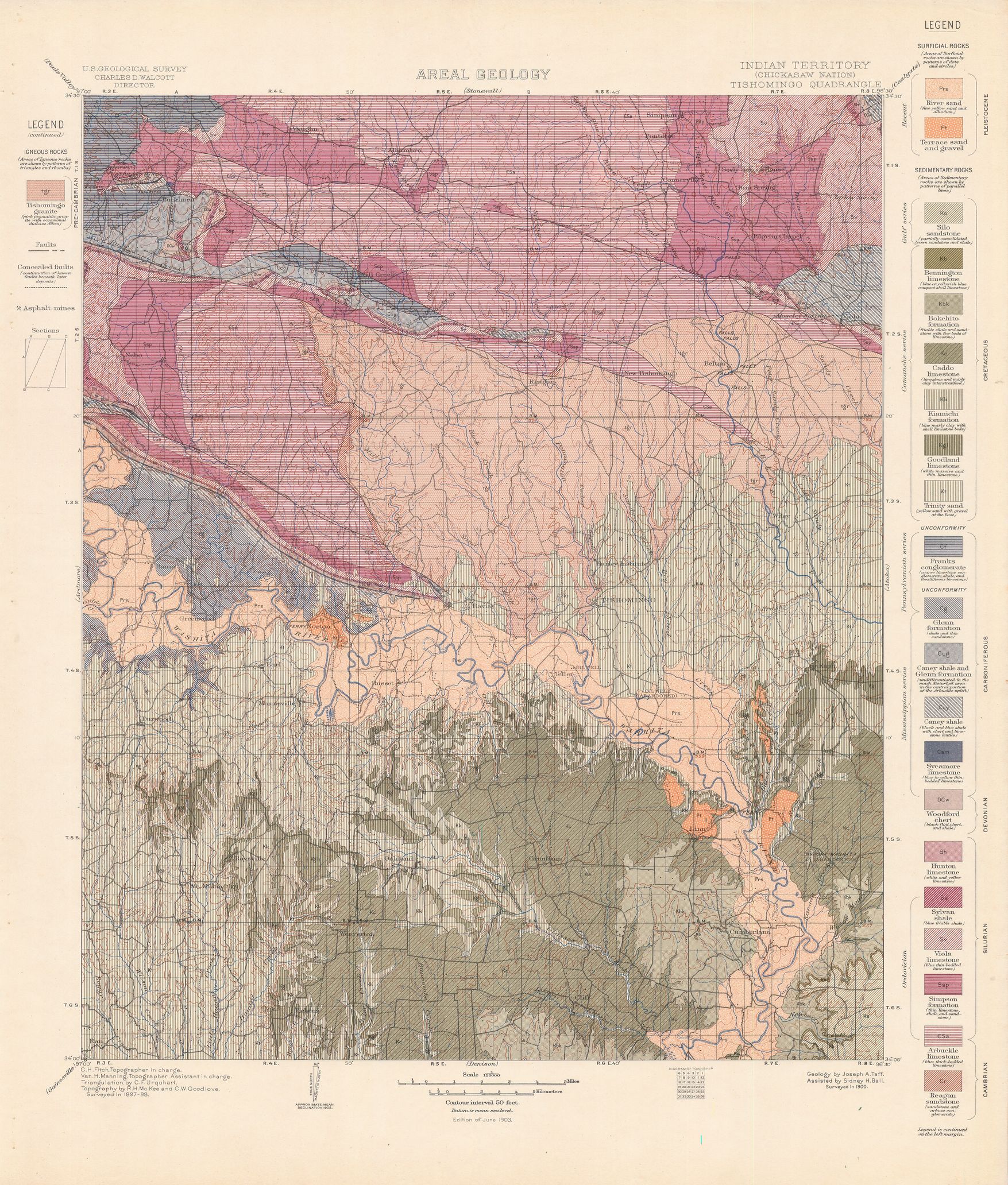
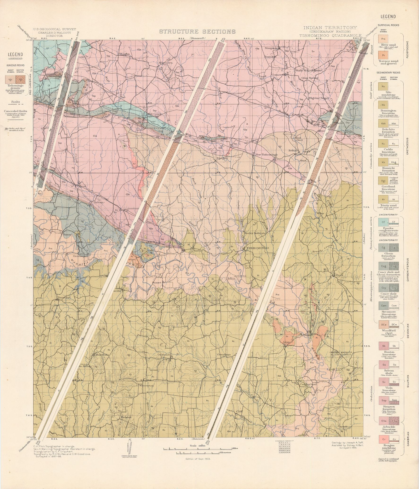
| dc.description | Tishomingo folio, Indian Territory | en |
| dc.format.extent | 89022271 bytes | en |
| dc.format.extent | 107303100 bytes | en |
| dc.format.extent | 107523756 bytes | en |
| dc.format.extent | 106955024 bytes | en |
| dc.format.extent | 106101028 bytes | en |
| dc.format.extent | 107376744 bytes | en |
| dc.format.extent | 106058080 bytes | en |
| dc.format.extent | 107556696 bytes | en |
| dc.format.extent | 107335652 bytes | en |
| dc.format.extent | 106199828 bytes | en |
| dc.format.extent | 102605388 bytes | en |
| dc.format.extent | 106546256 bytes | en |
| dc.format.extent | 106924920 bytes | en |
| dc.format.extent | 106762908 bytes | en |
| dc.format.extent | 106690796 bytes | en |
| dc.format.extent | 100308880 bytes | en |
| dc.format.extent | 98408404 bytes | en |
| dc.format.mimetype | image/tiff | |
| dc.format.mimetype | image/tiff | |
| dc.format.mimetype | image/tiff | |
| dc.format.mimetype | image/tiff | |
| dc.format.mimetype | image/tiff | |
| dc.format.mimetype | image/tiff | |
| dc.format.mimetype | image/tiff | |
| dc.format.mimetype | image/tiff | |
| dc.format.mimetype | image/tiff | |
| dc.format.mimetype | image/tiff | |
| dc.format.mimetype | image/tiff | |
| dc.format.mimetype | application/pdf | |
| dc.format.mimetype | image/tiff | |
| dc.format.mimetype | image/tiff | |
| dc.format.mimetype | image/tiff | |
| dc.format.mimetype | image/tiff | |
| dc.format.mimetype | image/tiff | |
| dc.language.iso | en_US | |
| dc.publisher | Geological Survey (United States) | |
| dc.relation.ispartofseries | Geologic Atlas of the United States | |
| dc.relation.ispartofseries | 98 | |
| dc.rights | No copyright; for more information see: https://rightsstatements.org/page/NoC-US/1.0/ | en |
| dc.rights.uri | https://rightsstatements.org/page/NoC-US/1.0/ | |
| dc.subject | Neogene - unnamed strata | en |
| dc.subject | Carboniferous - Franks conglomerate; Glenn formation; Caney shale; Sycamore limestone; Woodford chert | en |
| dc.subject | Cretaceous - Silo sandstone; Bennington limestone; Bokchito formation; Caddo limestone; Kiamichi formation; Goodland limestone; Trinity sand | en |
| dc.subject | Devonian - Woodford chert | en |
| dc.subject | Cambrian - Arbuckle limestone; Regan sandstone | en |
| dc.subject | Silurian - Hunton limestone; Sylvan shale; Viola limestone; Simpson formation; Arbuckle limestone | en |
| dc.subject | Pre-Cambrian - Tishomingo granite | en |
| dc.subject.lcsh | Geology -- Oklahoma -- Bryant County -- Maps | en |
| dc.subject.lcsh | Geology -- Oklahoma -- Carter County -- Maps | en |
| dc.subject.lcsh | Geology -- United States --Maps | en |
| dc.subject.lcsh | Geology -- Oklahoma -- Love County -- Maps | en |
| dc.subject.lcsh | Geology -- Oklahoma -- Murray County -- Maps | en |
| dc.subject.lcsh | Geology -- Oklahoma -- Marshall County -- Maps | en |
| dc.subject.lcsh | Geology -- Oklahoma -- Johnson County -- Maps | en |
| dc.subject.lcsh | Geology -- Oklahoma -- Coal County -- Maps | en |
| dc.title | Tishomingo folio, Indian Territory | en |
| dc.type | Image | en |
| dc.type | Map | en |
| dc.type | Book | en |
| dc.coverage.box | northlimit=34.5; westlimit=-97; southlimit=34; eastlimit=-96.5 | en |
| dc.coverage.point | 34:00:00N96:30:00W | en |