| dc.coverage.spatial | Sierra Gorda (Mexico, Querétaro) | en |
| dc.date.accessioned | 2011-08-29T19:52:38Z | |
| dc.date.available | 2011-08-29T19:52:38Z | |
| dc.date.created | 2009 | |
| dc.date.issued | 2011-08-29 | |
| dc.identifier.other | Location of original:Map Case B, Drawer 8 | |
| dc.identifier.other | Folder 47/11 | |
| dc.identifier.other | Image file name: CMLRSC00269.jpf | |
| dc.identifier.uri | https://hdl.handle.net/1969.1/126181 | |
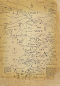
| dc.description | Printed copy of map of La Sierra Gorda. | en |
| dc.description | Print | en |
| dc.description | Caption: The original copy of this map was made in 1792 and was traced by me Sept. 12, 1941 from a copy in Prieto's "Estado de Tamaulipas." S. Chamberlain 272 | en |
| dc.format.extent | 59 x 50 inches | en |
| dc.publisher | Physical: Raiford Stripling, Architect | |
| dc.publisher | Digital: Cushing Memorial Library and Archives, Texas A&M University, Email: cushing-library@tamu.edu, Phone: 979-845-1951,Website: http://cushing.library.tamu.edu/ | |
| dc.relation.ispartof | The Raiford L. Stripling Architecture Collection | en |
| dc.rights | Original materials accessed by appointment only. | en |
| dc.rights | It is the users responsibility to secure permission from the copyright holders for publication of any materials. Permission must be obtained in writing prior to publication. Please contact the Cushing Memorial Library for further information. | en |
| dc.subject | Sierra Gorda (Mexico, Querétaro) | en |
| dc.subject | Maps | en |
| dc.title | Mapa de La Sierra Gorda | en |
| dc.type | Image | en |
| dc.type.genre | Technical drawings | en |